Unlikely Lincolnshire nature reserves (1): roadside verges, south of Ancaster

Uploader's Comments
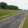
Roadside verges in this part of Lincolnshire are now recognised as valuable refuges for limestone flora - orchids amongst others. The wide verges here are some of a number now managed as nature reserves. This little lane once ran through from High Dike (the local name for Ermine Street) to Belton, connecting with routes to Syston and Barkston. It is now a dead end, petering out at the boundary of Barkston Heath aerodrome. The double yellow lines look very odd in a spot where traffic is next to nil. I can only suppose that they're meant to discourage people from parking on the verges - or might it have to do with emergency access to or from the airfield? See also [[2161809]]
Uploaded to Geograph by Stefan Czapski on 11 July 2009