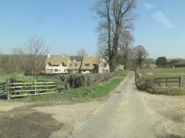
Colesbourne, Gloucestershire

« Gazetteer Entry
Upload Photo

Colesbourne, Gloucestershire

Other current and historical names

  • Colesborne
  • Coldsborne
  • Corberles
  • Parish/Community: Colesbourne
  • District/Borough: Cotswold
  • County: Gloucestershire
  • Region: South West
  • Category: Populated Place
  • Type: Village
  • Latitude/Longitude: 51°49'0"N 2°0'50"W
  • Eastings/Northings: 399130, 213124
  • OS Grid: SO991131
  • Mapcode Local: GBR 2ND.1LY
  • Mapcode Global: VHB24.1LML

Location and coordinates are for the approximate centre of Colesbourne within this administrative area. Geographic features and populated places may cross administrative borders.

BritishPlaceNames.uk is a Good Stuff website.