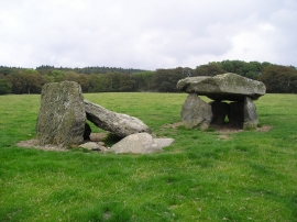
Coed Tan-y-bryn, Isle of Anglesey

« Gazetteer Entry
Upload Photo

Coed Tan-y-bryn, Isle of Anglesey

  • Parish/Community: Bodedern
  • Unitary Authority: Isle of Anglesey
  • Region: Wales
  • Category: Landcover
  • Type: Forest or Wood
  • Latitude/Longitude: 53°17'39"N 4°28'27"W
  • Eastings/Northings: 235192, 380333
  • OS Grid: SH351803
  • Mapcode Local: GBR HMBZ.TGT
  • Mapcode Global: WH42K.7GNC

Location and coordinates are for the approximate centre of Coed Tan-y-bryn within this administrative area. Geographic features and populated places may cross administrative borders.

BritishPlaceNames.uk is a Good Stuff website.