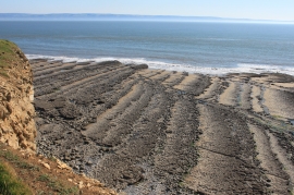
Castell y Dryw, Vale of Glamorgan

« Gazetteer Entry
Upload Photo

Castell y Dryw, Vale of Glamorgan

  • Parish/Community: St. Donats
  • Unitary Authority: Vale of Glamorgan
  • Region: Wales
  • Category: Geographic Feature
  • Type: Other Coastal Landform
  • Latitude/Longitude: 51°24'8"N 3°33'41"W
  • Eastings/Northings: 291468, 168191
  • OS Grid: SS914681
  • Mapcode Local: GBR HF.QSZC
  • Mapcode Global: VH5J4.60YT

Location and coordinates are for the approximate centre of Castell y Dryw within this administrative area. Geographic features and populated places may cross administrative borders.

BritishPlaceNames.uk is a Good Stuff website.